
ROYALTEK RBT2300 data downloader for Pocket PC (PPC)
HUNGARIAN VERSION in Word document
I recently purchased a Royaltek RBT-2300 Bluetooth GPS unit. This device
meets my needs perfectly:
sensitive
lifespan of the battery:> 17h (version shipped by
Cricel)
and most importantly "datalogger" function : it is capable
of storing up to 650000 points (time and position) in its
64mb internal memory,
The single drawback is that the provided software only runs on PCs,
and I needed an equivalent pocket PC software.
After having contacted Cricel and Royaltek, I came to the conclusion
that I had to develop my own software ...
I would like to clarify that it is not very fast ... but it includes interesting features that even the royaltek
sofware does not provide:
The software is freeware. It can only be distributed from
this web site. If you've appreciated it and want to support me for further
improvements, you can make a secure donation via PayPal. Be warmly thanked!
download the latest stable version v2007 :
DOWNLOAD PPC VERSION : .CAB here
Install it on the PPC. You will probably also need to install the. NET
FRAMEWORK from microsoft
.CAB install creates a directory "RBT_2300" under "program files" containing "RBT_2300.exe."
DOWNLOAD PC VERSION : .EXE
here
On the PC, the file itself is sufficient. No installation is required.
The code is identical to the PPC version described below. The only difference is the presence on the PC MMI of a SILENT button "" which is used to interrupt the NMEA frames broadcast (useful for debugging!)
Since version 1300, the RBT_2300 downloader has a language configuration.
Therefore, a MMI.txt file must be copied into the install directory.
For now, only the English and German versions are available (in addition to the default
French language ). All people of goodwill are welcome ;-)
english version (thank you Brendt ! )
Deutch version (thank you Tino)
Espagnol and Catalan (thanks Dany)
Hungarian (thanks K09)
Since v1400, the RBT_2300 downloader includes a function to apply geoid correction to dumped altitude values.
In order not to consume too much memory, I've chosen to generate a small geoid grid with a 1° step and an altitude accuracy of 1 m, which is good enough compared to the 5m GPS accuracy ...
The geoid grid is stored as an image file in PBM (portable bitmap) format, with pixel value set to the geoid + 110m. This leads to a very compact format, which is useful given the limited memory of a PDA

If you prefer to store the raw values (Mean Sea Level altitudes) just remove the geoid.pbm file which is in the install directory on the PCC). The only drawback is that when the program is launched, a message will pop up to remind you that the goid file is not present ...
The PC version, in contrast, does not include the geoid.pbm file. If you're interested in this function, just copy the file in the install directory.
Here is the geoid.pbm file
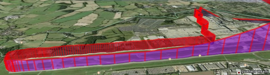
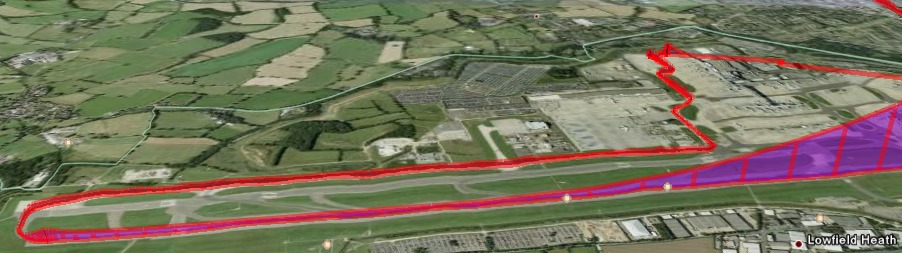
Should you still have some doubts on the utility of correcting the altitude using the geoid, here are two screenshots of the same flight take off in London Gatwick airport. The upper one is without geoid correction, the other with geoid computation ... no comment !
The very first time, a message "no preference file" will appear to
remind you that you must enter your user preferences:
 click OK to get rid of it.
and start the entry phase, preferably from the next screen by clicking on pref ...:
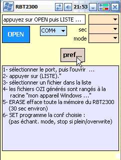
If you click pref ..., a second page should appear asking you to click Dir ...

enter the location to store your dumps: here the Compact Flash card. You can also enter the name of an existing folder. Do not enter anything in the area of the filename, it is useless!
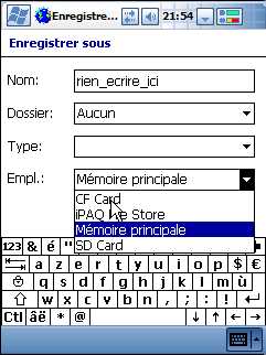
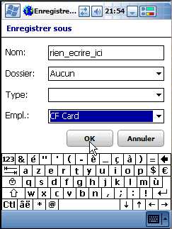
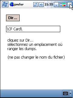
Once the location is determined, click OK; the text box will retain the selected directory . Incidentally a file pref.txt is created in the install directory. Close the window in the upper right and you'll be directed to the start screen:
pref.txt file contains also the COM port default value name. Warning, some PCs or bluetooth devices suffer from a bug (in .NET FrameWork): listed serial ports names end with random character like COM10c COM12i. In that case you will need to manually edit the pref.txt file to add the COM port you wish to use:
C:\Documents and Settings\Alain\Bureau\
COM2 OZI X24
and everything should work ...
You can also edit the default values "OZI X24" after the COM port number in the pref.txt file using one of the following values for the output format (OZI, GPX, NMEA) and for the multidump option (see below) (1, X, 24, X24)
values shall be separated with SPACE character.
eg : COM12 GPX 1
You have to choose the Bluetooth serial port .
Once the port is chosen, click OPEN ... it opens the port
(cool isn't it ;-))
new buttons should appear :
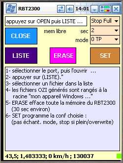
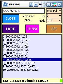
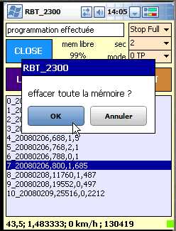
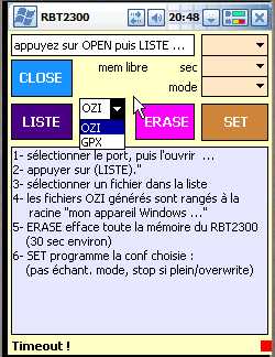
If you click LIST, the name of files in memory are listed:

The program then retrieves the available memory capacity : free mem 99%
For information, on the names of files, parameters behind the comma are:
To dump a file, click on the file name and then OK

Note that the time of the first fix in the file appears in the information area
if you just want to see the time without launching a dump do not confirm by clicking Cancel
If you click OK: the dump starts, you'll see frames progressing by the message:
>>> xxx / total frames to dump up to the end of file
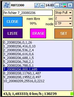
The dumped file is stored in the directory selected during the preferences process. Depending on the output format choice, you will get files:
OZIexplorerCE ( .plt)
GPX ( .gpx)
NIMEA ( .nmea)
here is an OziExplorerCE file :
OziExplorer Track Point File Version 2.1
WGS 84
Altitude is in Feet
Reserved 3
0,2,255,Compliments_Aeropic,0,0,2,8421376
0
43.51322, 1.49925,0, 653.9943, 39488.65,,15:33:51, 0.7908441
43.51322, 1.499253,0, 649.4207, 39488.65,,15:33:53, 0.4039021
43.51322, 1.499253,0, 646.2142, 39488.65,,15:33:55, 0.3498632
43.51322, 1.499253,0, 643.5519, 39488.65,,15:33:57, 0.2184534
...
useful lines include :
latitude, longitude, 0, altitude in feet, date and time in day fraction, , text time, speed.
(those two last parameters "text time, speed." are not used by OZI)
to open a .plt file under OZIce:
- launch OZIce on the PDA
- At the bottom click on Toolbars and then check track toolbar
- Click on "opening folder ..."
- Select the file. Plt
The track will appear on the map background.
You can then close the "track toolbar."
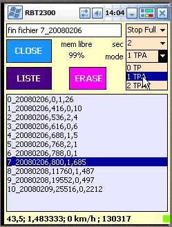
The program can be used to set the GPS configuration:
fill in the desired configuration using the pull-down menus (within 4
seconds ...), then click OK and SET
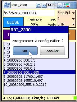
Finally, if you press ERASE after confirmation OK, the memory content is erased !
from version 1003 new functions have been added (see the middle of the screens capture images)
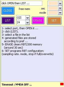
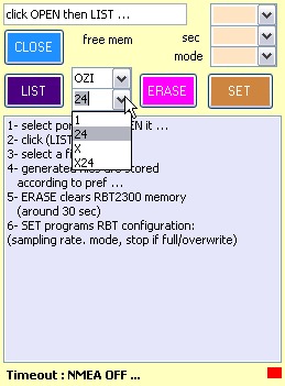
two pull down menus have appeared:
OZI, GPX or NMEA : output format selection OZI, GPX and NMEA
X or 1 : multidump fonction ...
If you select X (default) the dump of the selected file will automatically go on including the following files, provided they have been recorded under these conditions:
during the same day
in a single mode
A single output file is then generated.
thus, for example, if the memory contains:
0_20080210 mode 2
1_20080210 mode 2
2_20080210 mode 2
3_20080210 mode 1
a request to dump file 1 will automatically dump the linked file 2. The resulting file in the PPC will be named 1_20080210.plt
It can be very handy for long trips because the RBT2300 breaks
files into memory in order not to exceed about 4000 frames, it will avoid the
tedious job of appending files to rebuild your great trip!
If you select 1, a single file will be dumped at once.
Release 2.000 includes nex functions. "X options" (X ou X24) allow to dump the whole RBT 2300 memory in one click .
files are dumped:
one by on from the selected file in memory up to the end if you select "X".
grouped in a single file for every day (24h) if you select "X24"
New functions are accessible when clicking on the little green square at the bottom right of the screen.
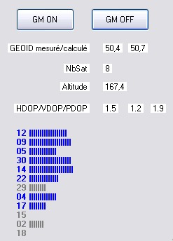
This form collects :
GGA and GSA frames decommutation result on GPS fix and satellites signals
local GEOID values measured by the GPS and computed by the software (here the error is in the range on 30 cm; not too bad !)
two buttons to switch ON/OFF the G-MOUSE function (same as royaltek software : very few interest !)
The RBT-2300 is a beautiful toy, coupled with the 17h CRICEL battery , it has remarkable autonomy and is easily forgoten in a pocket or backpack.
Enjoy your RBT during mountain trips. Here are the result of a day of skiing:
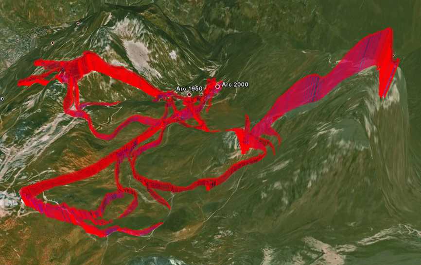
Google Earth DTM is not perfect on the red needle!
For the curious, here is my analysis of the RBT protocol.
keep me informed if everything works fine ! (please include your configuration) ...

version 2007 :
GPX <speed> tag is expressed in m/sec to be compliant with GpsBabel
version 2006 :
better accuracy for NMEA output
version 2004 :
added default values for output format and multidump option in pref file
version 2003 :
compatible with the new royaltek firmware
version 2002 :
bugs fixed in GPX files
added default COM port in pref.txt file
version 2000 :
one click dump function
added file number during dump : >>> n°_xxx/yyyy
bug fixed display of geoid and altitude was wrong when regional setting where set to English
version 1501 : added NMEA form
version 1402 : geoid is coded in a .pbm picture
version 1401 : increased accuracy in geoid computation
version 1400 :
altitude correction with geoid
The small GPS status square hides a button used to switch off G-MOUSE
version 1301 : bug fixed when pref.txt was not present
version 1300 : language management ...
version 1203 : removal of white lines in PLT which disrupted OZI ...
version 1202 : To be compatible with LOCr, NMEA frames checksum is calculated
version 1201 : When a dump file, already exists, the old version is overwritten
version 1200 : Adding the IHM capture preferences (path of the directory safeguard dumps)
version 1101 : bug fix on the negative longitudes and latitudes (South and West) in the frame NMEA
version 1100 : improvement in performance
version 1007 :
format NMEA
bug in GPX format (altitude was in feet...)
version 1006 : fixed a bug in sync frames LOG102 (some files could not finish)
version 1005 : fix a date OZI (crash on OS USA)
version 1004 : fix a date OZI